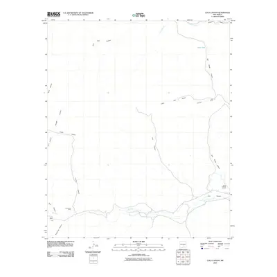
2010 Map of Loco Canyon
USGS Topo · Published 2010About this map
Rio Felix meanders through this landscape of deep drainages and cattle country, defining the hydrology of the southern reaches. The area is characterized by a series of significant canyons including Loco Canyon, Lincoln Canyon, and Salt House Canyon, which carve through the terrain and suggest the challenging topography of this part of Chaves County. Small-scale ranching and aviation infrastructure are evident, notably at the Flying H Ranch Airport and the R Vandewart Ranch. These features, along with names like Joy Ranch and Funk, point to a sparsely populated region where life revolves around water sources like Janey Tank and the seasonal flows of Crooked Creek. The map provides a detailed record of the road networks and ranch boundaries that have historically organized this rural New Mexico environment.
Find a feature on this map
18 named features on this map. Tap any name to fly to it.
Don’t see what you’re looking for? This feature index may not catch every label — zoom into the map to look around manually.
Map Details
Editions of this 2010 Loco Canyon Map
This is the sole edition of this map. No revisions or reprints were ever made.
Other maps of this area

1954 · Carlsbad
USGS Topo · 1:250,000

1955 · Roswell
USGS Topo · 1:250,000

1958 · Carlsbad
USGS Topo · 1:250,000

1958 · Roswell
USGS Topo · 1:250,000

1961 · Flying H
USGS Topo · 1:62,500

1962 · Roswell
USGS Topo · 1:250,000

1962 · Dunken
USGS Topo · 1:62,500

1963 · Clements Ranch
USGS Topo · 1:24,000

1963 · Deadman Lake
USGS Topo · 1:24,000
1963 · Elk
USGS Topo · 1:24,000