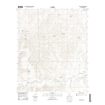
2013 Map of Loco Canyon
USGS Topo · Published 2013About this map
Rio Felix meanders through the southern portion of this landscape, anchoring a network of canyons and drainage systems in Chaves County. This 2013 survey illustrates a rural ranching environment where water management is central to the land's utility, marked by features such as Janey Tank and Crooked Cr. The terrain is deeply incised by named geographic features including Loco Canyon, Morgan Canyon, and Salt House Canyon. Transport in the area is defined by winding gravel and dirt routes, notably Picacho Canyon Rd and Felix Canyon Rd, which connect remote outposts like the R Vandewart Ranch. The presence of the Flying H Ranch Airport and the descriptively named Old Schoolhouse Rd suggests a history of localized infrastructure serving isolated homesteads and grazing lands.
Find a feature on this map
31 named features on this map. Tap any name to fly to it.
Don’t see what you’re looking for? This feature index may not catch every label — zoom into the map to look around manually.
Map Details
Editions of this 2013 Loco Canyon Map
This is the sole edition of this map. No revisions or reprints were ever made.
Other maps of this area

1954 · Carlsbad
USGS Topo · 1:250,000

1955 · Roswell
USGS Topo · 1:250,000

1958 · Carlsbad
USGS Topo · 1:250,000

1958 · Roswell
USGS Topo · 1:250,000

1961 · Flying H
USGS Topo · 1:62,500

1962 · Roswell
USGS Topo · 1:250,000

1962 · Dunken
USGS Topo · 1:62,500

1963 · Clements Ranch
USGS Topo · 1:24,000

1963 · Deadman Lake
USGS Topo · 1:24,000
1963 · Elk
USGS Topo · 1:24,000