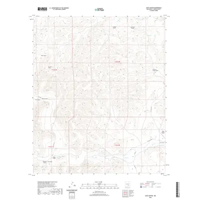
2020 Map of Loco Canyon
USGS Topo · Published 2020About this map
Rio Felix flows through the southeastern portion of this landscape, providing a primary drainage point for the numerous canyons that score the high desert terrain of Chaves County. This 2020 survey illustrates a deeply dissected topography where features like Salt House Canyon and Crooked Canyon run parallel toward the northeast, while others such as Pine Tree Canyon and Morgan Canyon converge from the west. The drainage network is further defined by ephemeral points like Crooked Cr and the livestock-related Janey Tank.
Find a feature on this map
22 named features on this map. Tap any name to fly to it.
Don’t see what you’re looking for? This feature index may not catch every label — zoom into the map to look around manually.
Map Details
Editions of this 2020 Loco Canyon Map
This is the sole edition of this map. No revisions or reprints were ever made.
Other maps of this area

1954 · Carlsbad
USGS Topo · 1:250,000

1955 · Roswell
USGS Topo · 1:250,000

1958 · Carlsbad
USGS Topo · 1:250,000

1958 · Roswell
USGS Topo · 1:250,000

1961 · Flying H
USGS Topo · 1:62,500

1962 · Roswell
USGS Topo · 1:250,000

1962 · Dunken
USGS Topo · 1:62,500

1963 · Clements Ranch
USGS Topo · 1:24,000

1963 · Deadman Lake
USGS Topo · 1:24,000
1963 · Elk
USGS Topo · 1:24,000