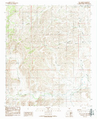
1989 Map of Loco Canyon
USGS Topo · Published 1989About this map
The Rio Felix corridor anchors the southern portion of this Chaves County landscape, where the watercourse meanders through a valley floor marked by essential rangeland infrastructure. Ranching life is documented through a network of water sources, including the Old Loco Well, Upper Loco Well, and Salt House Well, which were vital for livestock in this arid New Mexico terrain. The drainage systems of Loco Canyon and Little Salt House Canyon carve a complex series of draws into the uplands, illustrating the natural erosion patterns of the region. A remote Landing Strip and the presence of Janey Tank reflect the logistical adaptations required for managing large tracts of land. This survey, updated in the late 1980s, captures the enduring character of the high desert before modern developments altered the traditional ranching landscape.
Find a feature on this map
23 named features on this map. Tap any name to fly to it.
Don’t see what you’re looking for? This feature index may not catch every label — zoom into the map to look around manually.
Map Details
Editions of this 1989 Loco Canyon Map
This is the sole edition of this map. No revisions or reprints were ever made.
Other maps of this area

1954 · Carlsbad
USGS Topo · 1:250,000

1955 · Roswell
USGS Topo · 1:250,000

1958 · Carlsbad
USGS Topo · 1:250,000

1958 · Roswell
USGS Topo · 1:250,000

1961 · Flying H
USGS Topo · 1:62,500

1962 · Roswell
USGS Topo · 1:250,000

1962 · Dunken
USGS Topo · 1:62,500

1963 · Clements Ranch
USGS Topo · 1:24,000

1963 · Deadman Lake
USGS Topo · 1:24,000
1963 · Elk
USGS Topo · 1:24,000