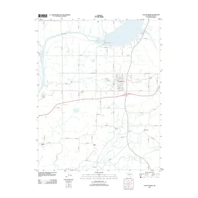
2012 Map of Locust Grove
USGS Topo · Published 2012About this map
Locust Grove serves as the primary hub of this Mayes County landscape, situated just south of the sprawling waters created by the Robert S Kerr Dam on the Neosho River. The map documents a rural network of family-named landmarks and small communities that have long defined this portion of eastern Oklahoma. Genealogists and local researchers can locate several significant burial grounds, including the Haner Cem, Bryan Cem, and Hogan Cem, which are scattered among the creek-fed hills. The geography is intricately carved by waterways like Crutchfield Br, Snake Cr, and Spring Cr, which converge near the settlements of Ballou and Iron Post. The infrastructure of the early 21st century is visible in the alignment of the Mayes Bridge and the grid of county roads that connect the outlying areas of Murphy to the central town center.
Find a feature on this map
59 named features on this map. Tap any name to fly to it.
Don’t see what you’re looking for? This feature index may not catch every label — zoom into the map to look around manually.
Map Details
Editions of this 2012 Locust Grove Map
This is the sole edition of this map. No revisions or reprints were ever made.
Other maps of this area

1896 · Pryor
USGS Topo · 1:125,000

1901 · Pryor
USGS Topo · 1:125,000

1954 · Tulsa
USGS Topo · 1:250,000

1958 · Tulsa
USGS Topo · 1:250,000

1963 · Tulsa
USGS Topo · 1:250,000
1970 · Chouteau
USGS Topo · 1:24,000
1970 · Rocky Point
USGS Topo · 1:24,000
1970 · Pryor
USGS Topo · 1:24,000
1971 · Salina
USGS Topo · 1:24,000
1971 · Salina SE
USGS Topo · 1:24,000