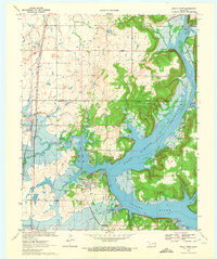
1970 Map of Rocky Point
USGS Topo · Published 1972About this map
Fort Gibson Reservoir dominates the landscape of this 1970s study, where the Neosho River widens into a complex network of bays and points at the border of Mayes and Wagoner Counties. The transition from riverine to reservoir environment is marked by numerous recreation sites, including Blue Bill Point Public Use Area and Snug Harbor Public Use Area. Transport patterns are defined by the Missouri-Kansas-Texas railroad corridor in the west, while an Old RR Grade winds through the hills near Big Bend, hinting at earlier logistics in the river valley. Small communities like Mazie and Leliaetta sit inland from the water, while the village of Yonkers is situated on the eastern shore. Genealogists will find the locations of Fisher Cem and Union Mission Cem preserved alongside industrial markers like the Filtration Plant and local Gravel Pit operations.
Find a feature on this map
31 named features on this map. Tap any name to fly to it.
Don’t see what you’re looking for? This feature index may not catch every label — zoom into the map to look around manually.
Map Details
Editions of this 1970 Rocky Point Map
2 editions found
Other maps of this area

1896 · Pryor
USGS Topo · 1:125,000

1901 · Muscogee
USGS Topo · 1:125,000

1901 · Pryor
USGS Topo · 1:125,000

1905 · Muscogee
USGS Topo · 1:125,000

1946 · Fort Smith
USGS Topo · 1:250,000

1948 · Hulbert
USGS Topo · 1:62,500

1948 · Wagoner
USGS Topo · 1:62,500

1950 · Wagoner
USGS Topo · 1:62,500

1950 · Hulbert
USGS Topo · 1:62,500

1954 · Tulsa
USGS Topo · 1:250,000