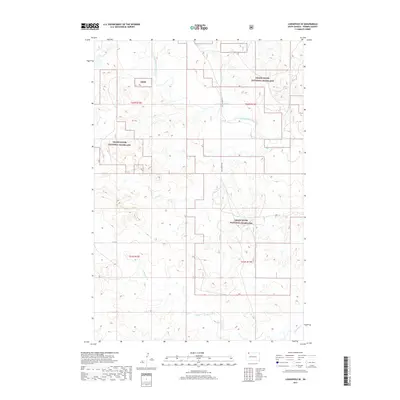
2017 Map of Lodgepole SE
USGS Topo · Published 2017About this map
Grand River National Grassland dominates this corner of Perkins County, where the landscape is defined by the winding course of the North Fork Grand River. This 2017 study illustrates the vast, open character of northwestern South Dakota, where the topography is shaped by the river valley and its various tributaries. Remote section lines and gravel paths like Castlebutte Rd and 111th St provide the only terrestrial markers across this protected prairie. In the southern portion of the map, Lodgepole Cr cuts through the terrain, further emphasizing the importance of water resources in this semi-arid region. The mapping reflects the contemporary administrative boundaries of the Grng, showcasing the modern balance of public land management and the historic survey grid.
Find a feature on this map
10 named features on this map. Tap any name to fly to it.
Don’t see what you’re looking for? This feature index may not catch every label — zoom into the map to look around manually.
Map Details
Editions of this 2017 Lodgepole SE Map
This is the sole edition of this map. No revisions or reprints were ever made.
Other maps of this area

1954 · Lemmon
USGS Topo · 1:250,000

1957 · Lemmon
USGS Topo · 1:250,000

1974 · Hettinger South
USGS Topo · 1:24,000

1974 · Kid Rich Butte
USGS Topo · 1:24,000

1974 · Haynes
USGS Topo · 1:24,000

1983 · Lodgepole SE
USGS Topo · 1:24,000

1983 · Cole Dam
USGS Topo · 1:24,000

1983 · Little Nasty Creek
USGS Topo · 1:24,000

1983 · Bison NW
USGS Topo · 1:24,000
1983 · Haynes SW
USGS Topo · 1:24,000