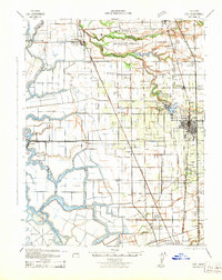
1942 Map of Lodi
USGS Topo · Published 1942About this map
Sanjon de los Mosquelumnes and the Mokelumne River define the intricate delta topography of this Central Valley landscape during the early 1940s. The region is a complex network of sloughs and reclaimed lands, including Staten Island, King Island, and Bouldin Island, which are separated by waterways like Hog Slough and Disappointment Slough. The irrigation-dependent agricultural economy is evident through features such as the Lower Sacramento Road Irrigation Canal and the Thornton Migratory Labor Camp located near New Hope Landing.
Find a feature on this map
59 named features on this map. Tap any name to fly to it.
Don’t see what you’re looking for? This feature index may not catch every label — zoom into the map to look around manually.
Map Details
Editions of this 1942 Lodi Map
This is the sole edition of this map. No revisions or reprints were ever made.
Other maps of this area

1894 · Lodi
USGS Topo · 1:125,000

1908 · Waterloo
USGS Topo · 1:31,680

1908 · Courtland
USGS Topo · 1:62,500

1908 · Lockeford
USGS Topo · 1:31,680

1909 · Clay
USGS Topo · 1:31,680

1910 · New Hope
USGS Topo · 1:31,680

1910 · Castle
USGS Topo · 1:31,680

1910 · Bouldin
USGS Topo · 1:31,680

1910 · Woodbridge
USGS Topo · 1:31,680

1910 · Bruceville
USGS Topo · 1:31,680