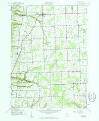
1942 Map of Lodi
USGS Topo · Published 1960About this map
The Lehigh Valley railroad corridor defines the western edge of this territory, following the high bluffs overlooking Seneca Lake. Surveyed just as the United States entered World War II, the landscape is organized around a network of crossroads settlements and numerous numbered schoolhouses. Deeply incised ravines cut through the terrain toward the lake, most notably at Silver Thread Falls near Lodi Station. While the village of Lodi serves as a primary hub, the interior is dotted with smaller hamlets like Lodi Center and Townsendville. The map illustrates a dense rural infrastructure typical of the Finger Lakes region in the early 1940s, including Round Sch and several family-named burial grounds such as Cronk Cem. Moving south into the town of Hector, the terrain rises toward the Backbone, marking the transition between Seneca and Schuyler counties.
Find a feature on this map
36 named features on this map. Tap any name to fly to it.
Don’t see what you’re looking for? This feature index may not catch every label — zoom into the map to look around manually.
Map Details
Editions of this 1942 Lodi Map
2 editions found
Other maps of this area

1893 · Ithaca
USGS Topo · 1:62,500

1895 · Ithaca
USGS Topo · 1:62,500

1898 · Watkins Glen
USGS Topo · 1:62,500

1901 · Watkins
USGS Topo · 1:62,500

1902 · Genoa
USGS Topo · 1:62,500

1902 · Ovid
USGS Topo · 1:62,500

1905 · Watkins Glen
USGS Topo · 1:125,000

1942 · Ovid
USGS Topo · 1:31,680

1942 · Dundee
USGS Topo · 1:24,000

1942 · Lodi
USGS Topo · 1:24,000