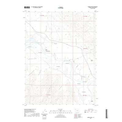
2019 Map of Lodore School
USGS Topo · Published 2019About this map
Browns Park in northwestern Colorado serves as a distinct low-elevation basin where the Green River meanders through a series of fertile alluvial flats known as bottoms. These features, including Flynn Bottom, Warren Bottom, and Grimes Bottom, highlight the historic reliance on river-adjacent lands for agriculture and settlement in this arid landscape. The presence of the Lodore School near the river's bend suggests a small but established community center serving the surrounding ranching country. The terrain rises sharply to the south toward Douglas Mountain, cut by numerous drainage features such as Yellow Jacket Draw and Goodman Gulch. Local springs like Hoy Spring and Sterling Spring provide essential water sources away from the main river channel, while the Hoy Dike Trail and Two Bar Ranch Loop Trail indicate a network of movement through the valley floor.
Find a feature on this map
34 named features on this map. Tap any name to fly to it.
Don’t see what you’re looking for? This feature index may not catch every label — zoom into the map to look around manually.
Map Details
Editions of this 2019 Lodore School Map
This is the sole edition of this map. No revisions or reprints were ever made.
Other maps of this area

1885 · Ashley
USGS Topo · 1:250,000

1952 · Willow Creek Butte
USGS Topo · 1:24,000

1952 · Swallow Canyon
USGS Topo · 1:24,000

1954 · Lodore School
USGS Topo · 1:24,000

1954 · Canyon of Lodore North
USGS Topo · 1:24,000

1954 · Vernal
USGS Topo · 1:250,000

1958 · Vernal
USGS Topo · 1:250,000

1960 · Vernal
USGS Topo · 1:250,000
1966 · Beaver Basin
USGS Topo · 1:24,000

1966 · Big Joe Basin
USGS Topo · 1:24,000