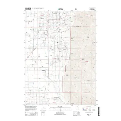
2014 Map of Logan
USGS Topo · Published 2014About this map
Logan serves as the focal point of this Cache Valley landscape, where the urban grid meets the steep ascent of the Cache National Forest. The map illustrates the complex water management of the region, featuring the Millville Providence Canal and the winding course of the Blacksmith Fork as it flows toward Hyrum. Academic and civic institutions are prominent, including the Utah State Univ campus and several municipal burial grounds like the Logan City Cem. To the east, the terrain rises sharply into the Bear River Range, carved by deep geological features such as Logan Canyon and Providence Canyon. This survey captures the mid-2010s suburban expansion of smaller communities like River Heights, Providence, and Nibley as they bridge the gap between the valley floor's agricultural roots and the protected mountain wilderness of Temple Baldy.
Find a feature on this map
139 named features on this map. Tap any name to fly to it.
Don’t see what you’re looking for? This feature index may not catch every label — zoom into the map to look around manually.
Map Details
Editions of this 2014 Logan Map
This is the sole edition of this map. No revisions or reprints were ever made.
Other maps of this area

1914 · Logan
USGS Topo · 1:125,000

1916 · Logan
USGS Topo · 1:125,000

1954 · Ogden
USGS Topo · 1:250,000

1955 · Paradise
USGS Topo · 1:24,000

1955 · Mount Pisgah
USGS Topo · 1:24,000

1958 · Ogden
USGS Topo · 1:250,000

1960 · Ogden
USGS Topo · 1:250,000

1961 · Logan
USGS Topo · 1:24,000
1962 · Wellsville
USGS Topo · 1:24,000
1964 · Smithfield
USGS Topo · 1:24,000