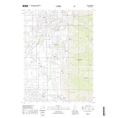
2020 Map of Logan
USGS Topo · Published 2020About this map
Logan and its surrounding communities in Cache County are defined by an intricate network of waterways and the sharp rise of the Wasatch Range to the east. The Logan River and its branches, including the Little Logan River, provide the backbone for a complex system of irrigation and municipal utility, visible in the many man-made channels like the Benson Canal and the Blacksmith Fork Hyrum Canal. This modern survey illustrates the proximity of urban centers like Providence, Millville, and Nibley to the steep wilderness of the Cache National Forest. To the east, the terrain climbs rapidly into landmarks such as Temple Baldy and Little Baldy, where deep ravines like Dry Canyon and Millville Canyon cut through the mountainside. The placement of the Logan Cem, Providence City Cem, and others provides valuable data for genealogists tracking local family histories within these established mountain valley settlements.
Find a feature on this map
41 named features on this map. Tap any name to fly to it.
Don’t see what you’re looking for? This feature index may not catch every label — zoom into the map to look around manually.
Map Details
Editions of this 2020 Logan Map
This is the sole edition of this map. No revisions or reprints were ever made.
Other maps of this area

1914 · Logan
USGS Topo · 1:125,000

1916 · Logan
USGS Topo · 1:125,000

1954 · Ogden
USGS Topo · 1:250,000

1955 · Paradise
USGS Topo · 1:24,000

1955 · Mount Pisgah
USGS Topo · 1:24,000

1958 · Ogden
USGS Topo · 1:250,000

1960 · Ogden
USGS Topo · 1:250,000

1961 · Logan
USGS Topo · 1:24,000
1962 · Wellsville
USGS Topo · 1:24,000
1964 · Smithfield
USGS Topo · 1:24,000