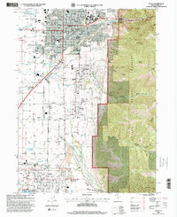
1998 Map of Logan
USGS Topo · Published 2001About this map
Logan serves as the focal point of this late-20th-century landscape, where the urban grid meets the rising slopes of the Cache National Forest. The map documents a significant religious and civic footprint, anchored by the Logan Temple and the Tabernacle. Educational and community infrastructure is well-defined, from the Logan HS to neighborhood institutions like Whittier Sch and Adams Sch.
Find a feature on this map
45 named features on this map. Tap any name to fly to it.
Don’t see what you’re looking for? This feature index may not catch every label — zoom into the map to look around manually.
Map Details
Editions of this 1998 Logan Map
This is the sole edition of this map. No revisions or reprints were ever made.
Other maps of this area

1914 · Logan
USGS Topo · 1:125,000

1916 · Logan
USGS Topo · 1:125,000

1954 · Ogden
USGS Topo · 1:250,000

1955 · Paradise
USGS Topo · 1:24,000

1955 · Mount Pisgah
USGS Topo · 1:24,000

1958 · Ogden
USGS Topo · 1:250,000

1960 · Ogden
USGS Topo · 1:250,000

1961 · Logan
USGS Topo · 1:24,000
1962 · Wellsville
USGS Topo · 1:24,000
1964 · Smithfield
USGS Topo · 1:24,000