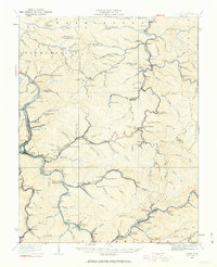
1926 Map of Logan
USGS Topo · Published 1963About this map
Logan serves as the focal point of this 1920s survey, situated along the Guyandotte River at a time when coal and timber transport defined the region's geography. The map reveals an intricate network of narrow valleys where settlements like Aracoma, Stollings, and Peach Creek are connected by the Chesapeake and Ohio and Appalachian rail lines. This industrial landscape is punctuated by numerous local institutions, including the Lane School, Sixmile School, and Polly School, which supported the growing coal camps of the era.
Find a feature on this map
167 named features on this map. Tap any name to fly to it.
Don’t see what you’re looking for? This feature index may not catch every label — zoom into the map to look around manually.
Map Details
Editions of this 1926 Logan Map
This is the sole edition of this map. No revisions or reprints were ever made.
Other maps of this area

1887 · Warfield
USGS Topo · 1:125,000

1891 · Oceana
USGS Topo · 1:125,000

1891 · Warfield
USGS Topo · 1:125,000

1892 · Huntington
USGS Topo · 1:125,000

1893 · Oceana
USGS Topo · 1:125,000

1898 · Huntington
USGS Topo · 1:125,000

1898 · Oceana
USGS Topo · 1:125,000

1899 · Charleston
USGS Topo · 1:125,000

1902 · Midkiff
USGS Topo · 1:62,500

1907 · Midkiff
USGS Topo · 1:62,500