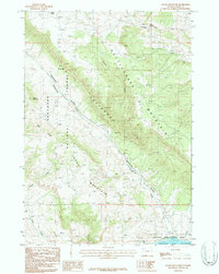
1987 Map of Logan Mountain
USGS Topo · Published 1987About this map
Logan Mountain and the high ridges of the Palisades dominate this high-elevation landscape in Park County, where the topography transitions from the high peaks of the Shoshone National Forest down toward the western edge of the Buffalo Bill Reservoir. This 1980s-era survey reveals an environment defined by its water sources and sharp relief, ranging from Trough Spring and Blue Springs in the north to the southern shoreline within Buffalo Bill State Park.
Find a feature on this map
20 named features on this map. Tap any name to fly to it.
Don’t see what you’re looking for? This feature index may not catch every label — zoom into the map to look around manually.
Map Details
Editions of this 1987 Logan Mountain Map
This is the sole edition of this map. No revisions or reprints were ever made.
Other maps of this area

1949 · Pat O'Hara Mountain
USGS Topo · 1:62,500

1949 · Cody
USGS Topo · 1:62,500

1951 · Cody
USGS Topo · 1:62,500

1955 · Cody
USGS Topo · 1:250,000

1957 · Wapiti
USGS Topo · 1:62,500

1957 · Devils Tooth
USGS Topo · 1:62,500

1958 · Cody
USGS Topo · 1:250,000

1962 · Cody
USGS Topo · 1:250,000

1980 · Carter Mountain
USGS Topo · 1:100,000

1980 · Cody
USGS Topo · 1:100,000