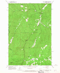
1964 Map of Lolo Hot Springs
USGS Topo · Published 1967About this map
Lolo Hot Springs serves as a focal point in this high-altitude landscape where the Lolo National Forest and Clearwater National Forest meet. Surveyed in the early 1960s, the map documents the remote Bitterroot Range along the Idaho-Montana border. A distinct network of transit paths is evident, ranging from the established road leading toward Lolo Pass to more primitive Jeep Trails and traditional Pack Trails that navigate the ridges. The terrain is marked by significant hydrological features including Snowshoe Falls and the convergence of the West Fork and East Fork of Lee Creek. Historical landmarks like the State Line Cabin and the Lee Creek Campground provide evidence of early forest management and recreational use. High-elevation clearings such as Elk Meadows and Packer Meadows break the dense timber of the surrounding peaks like Wagon Mountain and Rocky Peak.
Find a feature on this map
36 named features on this map. Tap any name to fly to it.
Don’t see what you’re looking for? This feature index may not catch every label — zoom into the map to look around manually.
Map Details
Editions of this 1964 Lolo Hot Springs Map
3 editions found
Other maps of this area

1911 · Lolo
USGS Topo · 1:250,000

1912 · Missoula
USGS Topo · 1:125,000

1913 · Lolo
USGS Topo · 1:250,000

1956 · Hamilton
USGS Topo · 1:250,000

1959 · Hamilton
USGS Topo · 1:250,000

1960 · Hamilton
USGS Topo · 1:250,000

1964 · Hamilton
USGS Topo · 1:250,000

1964 · Lolo Hot Springs
USGS Topo · 1:24,000

1964 · Garden Point
USGS Topo · 1:24,000

1964 · West Fork Butte
USGS Topo · 1:24,000