
1913 Map of Lolo
USGS Topo · Published 1913About this map
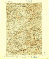
Moose City and scattered mining camps define this 1913 perspective of the high wilderness along the Idaho-Montana border. The industrial presence of the Clearwater Gold and Copper Company in the north and operations at Moscow Bar show the early twentieth-century rush for mineral wealth within the Clearwater National Forest. The landscape is dominated by complex ridgelines and water systems, including the North Fork Clearwater River and numerous high-altitude basins like Chamberlain Meadows.
Find a feature on this map
203 named features on this map. Tap any name to fly to it.
Don’t see what you’re looking for? This feature index may not catch every label — zoom into the map to look around manually.
Map Details
Editions of this 1913 Lolo Map
2 editions found
Other maps of this area

1901 · Hamilton
USGS Topo · 1:125,000

1911 · Lolo
USGS Topo · 1:250,000

1912 · Missoula
USGS Topo · 1:125,000

1914 · Avery
USGS Topo · 1:125,000

1917 · Avery
USGS Topo · 1:125,000

1918 · St Regis
USGS Topo · 1:125,000

1919 · St. Regis
USGS Topo · 1:125,000

1923 · Washington Creek
USGS Topo · 1:125,000

1924 · Weippe
USGS Topo · 1:125,000

1931 · Buffalo Hump
USGS Topo · 1:125,000