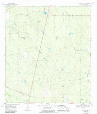
1969 Map of Loma Alta NE
USGS Topo · Published 1986About this map
Leopard Creek and its many tributaries, including Little Leopard Creek and Elm Creek, define the drainage patterns of this McMullen County landscape during the late 1960s. The area is characterized by sparse ranching outposts such as Hasete Ranch and Atkinson Ranch, which reflect the remote nature of the South Texas brush country before more intensive modern development. In the southern portion of the sheet, the small settlement of Loma Alta sits near a crossing of major local transit routes, adjacent to a designated Rest Area. Industrial activity is limited but present, seen in the Gravel Pit near Black Creek and a network of Pipeline corridors. Notable water features like Red Gate Tank and the uniquely named Devils Waterhole Creek suggest the importance of water management for livestock in this semi-arid environment.
Find a feature on this map
14 named features on this map. Tap any name to fly to it.
Don’t see what you’re looking for? This feature index may not catch every label — zoom into the map to look around manually.
Map Details
Editions of this 1969 Loma Alta NE Map
2 editions found
Other maps of this area

1920 · Mikeska
USGS Topo · 1:125,000

1929 · Simmons
USGS Topo · 1:62,500

1930 · Tilden
USGS Topo · 1:62,500

1937 · Loma Alta
USGS Topo · 1:62,500

1942 · Tilden
USGS Topo · 1:62,500

1953 · Crystal City
USGS Topo · 1:250,000

1955 · Crystal City
USGS Topo · 1:250,000

1961 · Crystal City
USGS Topo · 1:250,000

1968 · Crystal City
USGS Topo · 1:250,000
1969 · San Caja Hill
USGS Topo · 1:24,000