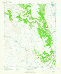
1963 Map of Loma Parda
USGS Topo · Published 1965About this map
Loma Parda Community occupies a striking position where the Mora River carves through the terrain, though by the mid-1960s, it is primarily identified as Loma Parda (Site). This map captures a significant landscape of Spanish land grants and western transit, featuring a large portion of the John Scolly Grant and the path of the Old Santa Fe Trail. The presence of a Stage Station and the Fort Union Corral near the trail's intersection with the Sapello River highlights the area's importance as a logistical hub for 19th-century travelers and military supplies. Irrigation infrastructure, such as the Upper Clyde Ditch and Upper Phoenix Ditch, illustrates the agricultural adaptations made to the arid New Mexico environment, while the Atchison Topeka and Santa Fe railroad corridor shows the modernization of this ancient transit route.
Find a feature on this map
23 named features on this map. Tap any name to fly to it.
Don’t see what you’re looking for? This feature index may not catch every label — zoom into the map to look around manually.
Map Details
Editions of this 1963 Loma Parda Map
This is the sole edition of this map. No revisions or reprints were ever made.
Other maps of this area

1889 · Las Vegas
USGS Topo · 1:125,000

1891 · Las Vegas
USGS Topo · 1:125,000

1892 · Watrous
USGS Topo · 1:125,000

1893 · Las Vegas
USGS Topo · 1:125,000

1894 · Watrous
USGS Topo · 1:125,000

1954 · Santa Fe
USGS Topo · 1:250,000

1958 · Santa Fe
USGS Topo · 1:250,000

1963 · Lake Isabel
USGS Topo · 1:24,000

1963 · Fort Union
USGS Topo · 1:24,000

1963 · Rainsville
USGS Topo · 1:24,000