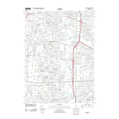
2012 Map of Lombard
USGS Topo · Published 2012About this map
Glen Ellyn and Bloomingdale anchor this detailed 2012 survey of DuPage County's western suburbs, showing a landscape defined by dense residential growth and complex transportation corridors. The suburban sprawl of the early 21st century is evident as major arteries like the Elgin Ohare Expy E and I-355 cut through established neighborhoods and newer developments such as Shorewood and Saddlewood.
Find a feature on this map
243 named features on this map. Tap any name to fly to it.
Don’t see what you’re looking for? This feature index may not catch every label — zoom into the map to look around manually.
Map Details
Editions of this 2012 Lombard Map
This is the sole edition of this map. No revisions or reprints were ever made.
Other maps of this area

1891 · Riverside
USGS Topo · 1:62,500

1893 · Riverside
USGS Topo · 1:62,500

1900 · Riverside
USGS Topo · 1:62,500

1900 · Highwood
USGS Topo · 1:62,500

1901 · Riverside
USGS Topo · 1:62,500

1908 · Wheaton
USGS Topo · 1:62,500

1923 · Barrington
USGS Topo · 1:62,500
1927 · Hinsdale
USGS Topo · 1:24,000

1927 · Arlington Heights
USGS Topo · 1:24,000

1928 · Elmhurst
USGS Topo · 1:24,000