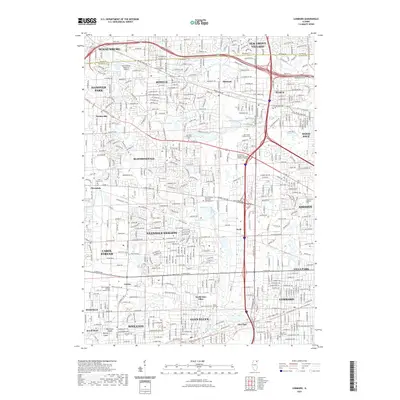
2021 Map of Lombard
USGS Topo · Published 2021About this map
Schaumburg and its surrounding suburbs define this modern Illinois landscape, where the Cook Co and DuPage Co boundary line threads through a dense network of residential and commercial development. The map details the transition from industrial and transport hubs like the Schaumburg Regional Airport to the established neighborhoods of Lombard and Glen Ellyn. Numerous religious and genealogical sites are preserved amidst the sprawl, including the Saint Stephens German Catholic Cem in Gretna and the Saint Pauls Addison Cem near Addison. Natural drainage patterns still influence the layout, with the East Branch Du Page River and Spring Brook winding through the terrain, while wetlands like Meacham Marsh and Circle Marsh persist as open pockets of green space between the major thoroughfares of Irving Park Rd and Thorndale Ave.
Find a feature on this map
136 named features on this map. Tap any name to fly to it.
Don’t see what you’re looking for? This feature index may not catch every label — zoom into the map to look around manually.
Map Details
Editions of this 2021 Lombard Map
This is the sole edition of this map. No revisions or reprints were ever made.
Other maps of this area

1891 · Riverside
USGS Topo · 1:62,500

1893 · Riverside
USGS Topo · 1:62,500

1900 · Riverside
USGS Topo · 1:62,500

1900 · Highwood
USGS Topo · 1:62,500

1901 · Riverside
USGS Topo · 1:62,500

1908 · Wheaton
USGS Topo · 1:62,500

1923 · Barrington
USGS Topo · 1:62,500
1927 · Hinsdale
USGS Topo · 1:24,000

1927 · Arlington Heights
USGS Topo · 1:24,000

1928 · Elmhurst
USGS Topo · 1:24,000