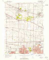
1953 Map of Lombard
USGS Topo · Published 1955About this map
Glen Ellyn and Lombard anchor this mid-century portrait of DuPage County, where the transition from rural prairie to suburban sprawl is well underway. The landscape is defined by the heavy presence of rail corridors like the Chicago Milwaukee St Paul and Pacific and the Chicago Great Western, which shaped the early development of towns like Roselle, Itasca, and Bloomingdale. Several country clubs, including Medinah Country Club and Glen Oak Country Club, occupy large tracts of land, signaling the region's mid-century shift toward a residential and leisure-oriented economy.
Find a feature on this map
70 named features on this map. Tap any name to fly to it.
Don’t see what you’re looking for? This feature index may not catch every label — zoom into the map to look around manually.
Map Details
Editions of this 1953 Lombard Map
This is the sole edition of this map. No revisions or reprints were ever made.
Other maps of this area

1891 · Riverside
USGS Topo · 1:62,500

1893 · Riverside
USGS Topo · 1:62,500

1900 · Riverside
USGS Topo · 1:62,500

1900 · Highwood
USGS Topo · 1:62,500

1901 · Riverside
USGS Topo · 1:62,500

1908 · Wheaton
USGS Topo · 1:62,500

1923 · Barrington
USGS Topo · 1:62,500
1927 · Hinsdale
USGS Topo · 1:24,000

1927 · Arlington Heights
USGS Topo · 1:24,000

1928 · Elmhurst
USGS Topo · 1:24,000