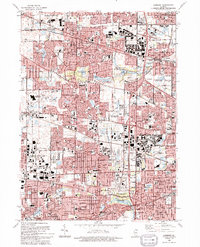
1993 Map of Lombard
USGS Topo · Published 1993About this map
Glen Ellyn, Lombard, and Wheaton anchor the southern portion of this landscape, showcasing the dense residential and suburban development of the early 1990s. The map illustrates a highly managed environment where natural spaces are preserved within an extensive system of county forest preserves, such as Churchill Woods Co For Presv and Swift Meadows Co For Presv. These greenbelts follow the corridors of the East Branch Du Page River and Salt Creek, providing a stark contrast to the surrounding grid of residential neighborhoods and commercial centers like Northland Mall.
Find a feature on this map
75 named features on this map. Tap any name to fly to it.
Don’t see what you’re looking for? This feature index may not catch every label — zoom into the map to look around manually.
Map Details
Editions of this 1993 Lombard Map
This is the sole edition of this map. No revisions or reprints were ever made.
Other maps of this area

1891 · Riverside
USGS Topo · 1:62,500

1893 · Riverside
USGS Topo · 1:62,500

1900 · Riverside
USGS Topo · 1:62,500

1900 · Highwood
USGS Topo · 1:62,500

1901 · Riverside
USGS Topo · 1:62,500

1908 · Wheaton
USGS Topo · 1:62,500

1923 · Barrington
USGS Topo · 1:62,500
1927 · Hinsdale
USGS Topo · 1:24,000

1927 · Arlington Heights
USGS Topo · 1:24,000

1928 · Elmhurst
USGS Topo · 1:24,000