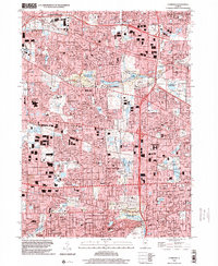
1998 Map of Lombard
USGS Topo · Published 2002About this map
Glen Ellyn and surrounding DuPage County communities are captured here during a period of dense suburban infill at the close of the twentieth century. The landscape is defined by the dual presence of extensive residential developments and the preservation of green space through the Forest Preserve District of DuPage County, notably at Mallard Lake Co For Presv and Churchill Woods Co For Presv. Transportation corridors like the Chicago and North Western and Illinois Central Gulf railroads continue to anchor the region's historic rail-oriented growth, connecting settlements like Roselle, Lombard, and Wheaton. Significant local landmarks such as the Schaumburg Airpark and the Stratford Square Shopping Center reflect the commercial evolution of the area, while numerous parochial institutions like Our Lady Queen of Peace Ch and St Pauls Cem provide vital touchstones for genealogical research.
Find a feature on this map
122 named features on this map. Tap any name to fly to it.
Don’t see what you’re looking for? This feature index may not catch every label — zoom into the map to look around manually.
Map Details
Editions of this 1998 Lombard Map
This is the sole edition of this map. No revisions or reprints were ever made.
Other maps of this area

1891 · Riverside
USGS Topo · 1:62,500

1893 · Riverside
USGS Topo · 1:62,500

1900 · Riverside
USGS Topo · 1:62,500

1900 · Highwood
USGS Topo · 1:62,500

1901 · Riverside
USGS Topo · 1:62,500

1908 · Wheaton
USGS Topo · 1:62,500

1923 · Barrington
USGS Topo · 1:62,500
1927 · Hinsdale
USGS Topo · 1:24,000

1927 · Arlington Heights
USGS Topo · 1:24,000

1928 · Elmhurst
USGS Topo · 1:24,000