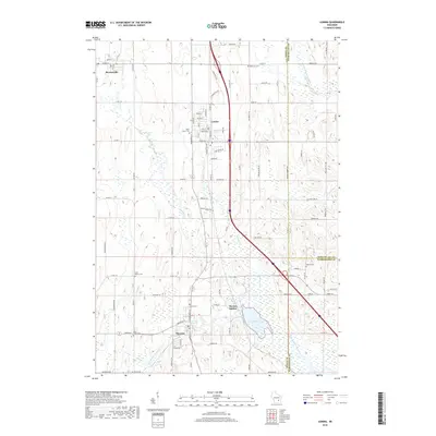
2018 Map of Lomira
USGS Topo · Published 2018About this map
Lomira and Theresa anchor this Dodge County landscape, situated at a major regional transit corridor. The map highlights the agricultural and rural character of the area, punctuated by a series of local burial grounds including Ebenezer Cem and Saint Peters Cem. Water resources are a defining feature, with the East Branch Rock River winding through the southern section near Theresa, while Crystal Spring and the 144 Reservoir indicate the importance of local hydrography. The inclusion of Theresa Station and Brownsville shows the distribution of smaller hubs that supported the surrounding farmsteads and rural residences. Movement through the quadrangle is facilitated by a dense network of county roads and local lanes such as Hiawatha Rd and W Bend Rd, reflecting the modern infrastructure overlaying a long-established settlement pattern.
Find a feature on this map
90 named features on this map. Tap any name to fly to it.
Don’t see what you’re looking for? This feature index may not catch every label — zoom into the map to look around manually.
Map Details
Editions of this 2018 Lomira Map
This is the sole edition of this map. No revisions or reprints were ever made.
Other maps of this area

1904 · Hartford
USGS Topo · 1:62,500

1955 · Waupun
USGS Topo · 1:62,500

1955 · Campbellsport
USGS Topo · 1:62,500

1955 · Horicon
USGS Topo · 1:62,500

1957 · Madison
USGS Topo · 1:250,000

1959 · Hartford
USGS Topo · 1:62,500

1959 · Nenno
USGS Topo · 1:24,000

1959 · Allenton
USGS Topo · 1:24,000

1960 · Madison
USGS Topo · 1:250,000
1974 · Campbellsport
USGS Topo · 1:24,000