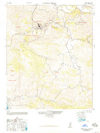
1948 Map of Lompoc Hills
USGS Topo · Published 1948About this map
The Johns Manville Plant stands as a focal point of industrial activity in the La Mission district, marking a period of significant mineral extraction in the hills south of the Santa Ynez River. Numerous Diatomaceous Earth Quarries are etched into the terrain of Vieja De La Purisima and Canada De Salsipuedes, revealing the scale of the diatomite mining operations that dominated the local economy in the late 1940s. These industrial sites are contrasted by the rural landscape to the south, where the Jalama School and Jalama Ranch serve the remote coastal canyons.
Find a feature on this map
25 named features on this map. Tap any name to fly to it.
Don’t see what you’re looking for? This feature index may not catch every label — zoom into the map to look around manually.
Map Details
Editions of this 1948 Lompoc Hills Map
This is the sole edition of this map. No revisions or reprints were ever made.
Other maps of this area

1905 · Guadalupe
USGS Topo · 1:125,000

1905 · Lompoc
USGS Topo · 1:125,000

1942 · Point Arguello
USGS Topo · 1:62,500

1942 · Guadalupe
USGS Topo · 1:125,000

1942 · Lompoc
USGS Topo · 1:125,000

1942 · Lompoc
USGS Topo · 1:62,500

1942 · Pt. Conception
USGS Topo · 1:62,500

1943 · Lompoc
USGS Topo · 1:125,000

1947 · Lompoc
USGS Topo · 1:24,000
1947 · Santa Rosa Hills
USGS Topo · 1:24,000