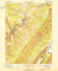
1951 Map of Lonaconing
USGS Topo · Published 1951About this map
The steep topography of Dans Mountain and Knobly Mtn defines this industrial corridor in the early 1950s. The Georges Creek Valley serves as the primary artery for both transportation and settlement, where the Cumberland and Pennsylvania railroad connects a string of mining towns from Carlos Junction through Midland to Lonaconing. The landscape bears the physical marks of its extractive economy, with numerous strip mines and family-named landmarks like Warner Cem and Neff Cem reflecting generations of local residency. Notable local elevations such as Dans Rock and Wolf Rock overlook the valley, while the southern portion of the sheet follows the Potomac River along the Maryland West Virginia border. The presence of the Western Maryland and Baltimore and Ohio railroads near Rawlings underscores the region's importance as a mid-century logistical hub for coal and freight.
Find a feature on this map
62 named features on this map. Tap any name to fly to it.
Don’t see what you’re looking for? This feature index may not catch every label — zoom into the map to look around manually.
Map Details
Editions of this 1951 Lonaconing Map
2 editions found
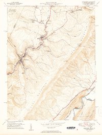
Other maps of this area

1891 · Romney
USGS Topo · 1:125,000

1895 · Piedmont
USGS Topo · 1:125,000

1898 · Frostburg
USGS Topo · 1:62,500

1899 · Grantsville
USGS Topo · 1:62,500

1901 · Frostburg
USGS Topo · 1:62,500

1904 · Grantsville
USGS Topo · 1:62,500

1908 · Frostburg
USGS Topo · 1:62,500

1919 · Elk Garden
USGS Topo · 1:48,000

1920 · Elk Garden
USGS Topo · 1:48,000

1920 · Keyser
USGS Topo · 1:62,500