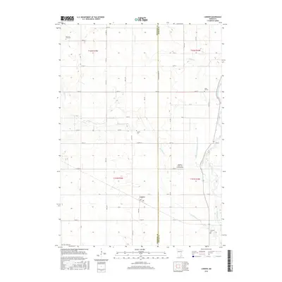
2016 Map of London
USGS Topo · Published 2016About this map
The Freeborn and Mower County line bisects this agricultural landscape, where the small settlement of London serves as a central point of reference. Geologic and human history intersect along the eastern edge of the quadrangle, where the Cedar River and Judicial Ditch Number Seventyseven manage the drainage of the fertile southern Minnesota plains. Several small family and community burial grounds, including the Kennevan Family Cem and Woodbury Cem, are scattered across the township, providing essential records for genealogical research in this rural district. The presence of Radloff's Cedar View Farms Airport indicates the continued importance of private aviation in managing these large agricultural holdings. Waterways like Orchard Cr and Woodbury Cr weave through a network of section roads such as Co Hwy 34 and 160th St, defining the long-established surveyor's grid that dictates the regional land use pattern.
Find a feature on this map
45 named features on this map. Tap any name to fly to it.
Don’t see what you’re looking for? This feature index may not catch every label — zoom into the map to look around manually.
Map Details
Editions of this 2016 London Map
This is the sole edition of this map. No revisions or reprints were ever made.
Other maps of this area

1954 · Hayward
USGS Topo · 1:62,500

1954 · Austin
USGS Topo · 1:62,500

1954 · Mason City
USGS Topo · 1:250,000

1957 · Mason City
USGS Topo · 1:250,000

1958 · Mason City
USGS Topo · 1:250,000

1972 · St. Ansgar
USGS Topo · 1:24,000

1972 · Northwood
USGS Topo · 1:24,000
1972 · Carpenter
USGS Topo · 1:24,000
1982 · Austin East
USGS Topo · 1:24,000

1982 · Hayward
USGS Topo · 1:24,000