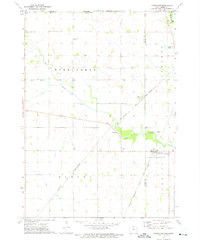
1972 Map of Carpenter
USGS Topo · Published 1975About this map
The Cedar River flows through the northeastern corner of this landscape along the Iowa-Minnesota border, marking a transition from the riparian environment to the structured agricultural townships of Barton, Otranto, and Newburg. In the early 1970s, the region was defined by a intersection of rail lines and small settlements. Carpenter sits at the junction of the Chicago Milwaukee St Paul and Pacific and the Chicago and North Western railroads, serving as a hub for local transit and trade. Near the town, the Newburg Cem and a nearby Gravel Pit offer specific landmarks for local history. To the northwest, Meltonville remains a distinct point along the rail corridor, while Deer Creek meanders through the central fields, passing the Deer Creek Ch and several family or community burying grounds like the London and Deer Creek Cem.
Find a feature on this map
24 named features on this map. Tap any name to fly to it.
Don’t see what you’re looking for? This feature index may not catch every label — zoom into the map to look around manually.
Map Details
Editions of this 1972 Carpenter Map
This is the sole edition of this map. No revisions or reprints were ever made.
Other maps of this area

1954 · Hayward
USGS Topo · 1:62,500

1954 · Austin
USGS Topo · 1:62,500

1954 · Mason City
USGS Topo · 1:250,000

1957 · Mason City
USGS Topo · 1:250,000

1958 · Mason City
USGS Topo · 1:250,000

1972 · St. Ansgar
USGS Topo · 1:24,000

1972 · Osage SW
USGS Topo · 1:24,000

1972 · Manly
USGS Topo · 1:24,000

1972 · Northwood
USGS Topo · 1:24,000
1972 · Grafton
USGS Topo · 1:24,000