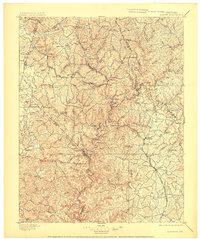
1897 Map of London
USGS Topo · Published 1904About this map
Mt. Vernon and the surrounding plateau regions of Laurel and Rockcastle counties are defined by a complex network of river systems and early rail transport. The Louisville and Nashville Railroad serves as the primary artery for the region, splitting into the Knoxville Branch and Central Division to connect remote hamlets like Wildie and Brodhead. This late nineteenth-century landscape is deeply dissected by the winding Rockcastle River and its numerous tributaries, including Horse Lick Creek and the Middle Fork. Named elevations such as Cash Knob and Sutton Knob rise above a rural interior populated by small settlements like Livingston, Bee Lick, and Cedarville. The presence of Gum Sulphur suggests the early importance of local mineral springs, while the intricate topography illustrates the challenges faced by early settlers navigating the Cumberland Plateau.
Find a feature on this map
110 named features on this map. Tap any name to fly to it.
Don’t see what you’re looking for? This feature index may not catch every label — zoom into the map to look around manually.
Map Details
Editions of this 1897 London Map
5 editions found

Other maps of this area

1886 · Cumberland Gap
USGS Topo · 1:125,000

1888 · Cumberland Gap
USGS Topo · 1:125,000

1890 · Williamsburg
USGS Topo · 1:125,000

1891 · Manchester
USGS Topo · 1:125,000

1891 · Cumberland Gap
USGS Topo · 1:125,000

1892 · Richmond
USGS Topo · 1:125,000

1892 · Beattyville
USGS Topo · 1:125,000

1893 · London
USGS Topo · 1:125,000

1894 · Williamsburg
USGS Topo · 1:125,000

1897 · Richmond
USGS Topo · 1:125,000