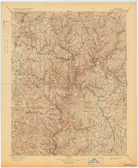
1897 Map of London
USGS Topo · Published 1932About this map
The Rockcastle River snakes through the center of this terrain, carving a deep path through the Cumberland Plateau of southeastern Kentucky. This late-nineteenth-century survey by E.C. Barnard illustrates a region defined by its rugged topography and the expansion of the Louisville and Nashville R. R.. The railway's presence is a central theme, with the Knoxville Branch connecting established mountain hubs like Mt. Vernon and London to smaller whistle-stops such as Maretburg and Livingston. Local industry and rural life are visible in the proximity of settlements to water sources like Horse Lick Cr. and Raccoon Cr.. High points like Brushy Mtn. and Sutton Knob dominate the landscape, while the intricate network of creeks illustrates the traditional drainage patterns that dictated early road and settlement placement before modern highway development.
Find a feature on this map
87 named features on this map. Tap any name to fly to it.
Don’t see what you’re looking for? This feature index may not catch every label — zoom into the map to look around manually.
Map Details
Editions of this 1897 London Map
5 editions found

Other maps of this area

1886 · Cumberland Gap
USGS Topo · 1:125,000

1888 · Cumberland Gap
USGS Topo · 1:125,000

1890 · Williamsburg
USGS Topo · 1:125,000

1891 · Manchester
USGS Topo · 1:125,000

1891 · Cumberland Gap
USGS Topo · 1:125,000

1892 · Richmond
USGS Topo · 1:125,000

1892 · Beattyville
USGS Topo · 1:125,000

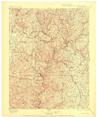
1893 · London
USGS Topo · 1:125,000

1894 · Williamsburg
USGS Topo · 1:125,000

1897 · Richmond
USGS Topo · 1:125,000