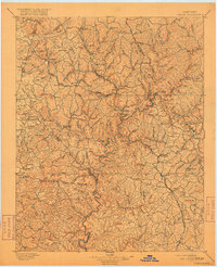
1897 Map of London
USGS Topo · Published 1917About this map
The Rockcastle River snakes through a complex topography of ridges and hollows in this late 19th-century survey of the London and Mt. Vernon region. The landscape is defined by the intersection of early rail lines and the drainage basins of the Big Laurel River and Little Laurel River. The Louisville and Nashville RR. and its Knoxville Branch serve as the primary conduits for commerce and transit, connecting established hubs like Brodhead and East Bernstadt to the broader Kentucky network.
Find a feature on this map
134 named features on this map. Tap any name to fly to it.
Don’t see what you’re looking for? This feature index may not catch every label — zoom into the map to look around manually.
Map Details
Editions of this 1897 London Map
5 editions found

Other maps of this area

1886 · Cumberland Gap
USGS Topo · 1:125,000

1888 · Cumberland Gap
USGS Topo · 1:125,000

1890 · Williamsburg
USGS Topo · 1:125,000

1891 · Manchester
USGS Topo · 1:125,000

1891 · Cumberland Gap
USGS Topo · 1:125,000

1892 · Richmond
USGS Topo · 1:125,000

1892 · Beattyville
USGS Topo · 1:125,000

1893 · London
USGS Topo · 1:125,000

1894 · Williamsburg
USGS Topo · 1:125,000

1897 · Richmond
USGS Topo · 1:125,000