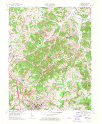
1969 Map of London
USGS Topo · Published 1972About this map
The Louisville and Nashville railroad corridor anchors the western edge of this Laurel County landscape, connecting the coal-era settlements of East Bernstadt and Pittsburg. At the end of the 1960s, the terrain shows a mix of established rural communities and evolving infrastructure, with the Daniel Boone Parkway cutting across the southern portion near London. The topography is defined by the winding course of the Laurel River and Raccoon Creek, with residential clusters such as McWhorter and Maplesville scattered among the ridges. Local genealogy is well-preserved through several country churches and burial grounds, including Hazel Green Ch, Mt Carmel Ch, and the Olive-Gilead Cem. A notable Strip Mine north of East Bernstadt reflects the region's industrial ties, while the Daniel Boone National Forest provides a northern boundary for the settled areas.
Find a feature on this map
63 named features on this map. Tap any name to fly to it.
Don’t see what you’re looking for? This feature index may not catch every label — zoom into the map to look around manually.
Map Details
Editions of this 1969 London Map
2 editions found
Other maps of this area

1891 · Manchester
USGS Topo · 1:125,000

1893 · London
USGS Topo · 1:125,000

1897 · London
USGS Topo · 1:125,000

1952 · Portersburg
USGS Topo · 1:24,000

1952 · Blackwater
USGS Topo · 1:24,000

1952 · Lily
USGS Topo · 1:24,000

1952 · London SW
USGS Topo · 1:24,000

1952 · Bernstadt
USGS Topo · 1:24,000

1952 · London
USGS Topo · 1:24,000

1953 · Livingston
USGS Topo · 1:24,000