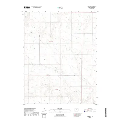
2018 Map of Lone Butte
USGS Topo · Published 2018About this map
Lone Butte stands as a prominent topographical landmark within this high-plains landscape of Logan County. The land is defined by a series of named drainage and range divisions including Kiowa, Jayhawk, and Indian, which likely reflect historical ranching or township identities from the region's cattle and agricultural heritage. The rectilinear grid of the Public Land Survey System is clearly marked through townships t14s r35w and t14s r34w, intersected by a sparse network of section-line roads such as Co RD 240 and Co RD 270. Other localized markers like Hunter and Gold provide further context for how this expansive territory was subdivided and named by early settlers and surveyors.
Find a feature on this map
13 named features on this map. Tap any name to fly to it.
Don’t see what you’re looking for? This feature index may not catch every label — zoom into the map to look around manually.
Map Details
Editions of this 2018 Lone Butte Map
This is the sole edition of this map. No revisions or reprints were ever made.
Other maps of this area

1939 · Pence
USGS Topo · 1:62,500

1941 · Pence
USGS Topo · 1:62,500

1955 · Scott City
USGS Topo · 1:250,000

1958 · Scott City
USGS Topo · 1:250,000

1968 · Russell Springs 3 NE
USGS Topo · 1:24,000

1969 · Russell Springs 2 NE
USGS Topo · 1:24,000

1969 · Russell Springs 2 SE
USGS Topo · 1:24,000

1972 · Russell Springs
USGS Topo · 1:24,000
1972 · Russell Springs NE
USGS Topo · 1:24,000
1974 · Lone Butte
USGS Topo · 1:24,000