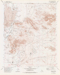
1973 Map of Lone Butte
USGS Topo · Published 1976About this map
China Lake Naval Weapons Center dominates this mid-1970s landscape at the intersection of Kern and San Bernardino counties. The infrastructure of the Cold War era is evident through the extensive network of Street grids, the U S Government Railroad, and various observation and radio towers. This military installation is bordered by the dramatic heights of the Argus Range, which rises sharply above the desert floor. The map details a landscape of strategic importance, featuring specialized facilities such as the Magazine Road, Normal E Base, and the Pilot Plant Road. For the researcher, the map preserves the precise locations of support structures including numerous Water Tanks, a Reservoir, and several Borrow Pits that supported the construction and maintenance of the desert complex during its peak operations.
Find a feature on this map
32 named features on this map. Tap any name to fly to it.
Don’t see what you’re looking for? This feature index may not catch every label — zoom into the map to look around manually.
Map Details
Editions of this 1973 Lone Butte Map
This is the sole edition of this map. No revisions or reprints were ever made.
Other maps of this area

1915 · Searles Lake
USGS Topo · 1:250,000

1947 · Trona
USGS Topo · 1:250,000

1948 · Trona
USGS Topo · 1:250,000

1949 · Trona
USGS Topo · 1:62,500

1949 · Searles Lake
USGS Topo · 1:62,500

1950 · Searles Lake
USGS Topo · 1:62,500

1950 · Trona
USGS Topo · 1:62,500

1953 · Mountain Springs Canyon
USGS Topo · 1:62,500

1953 · Ridgecrest
USGS Topo · 1:62,500

1953 · Trona
USGS Topo · 1:250,000