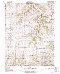
1952 Map of Lone Elm
USGS Topo · Published 1986About this map
Lone Elm and the surrounding township lands of Clark Fork and North Moniteau are documented here during the early 1950s, with later updates from the 1980s. This agricultural landscape in Cooper County is defined by its rural institutions, many of which are linked to family and community heritage. The map captures a high density of rural burial grounds and houses of worship, including Walnut Grove Ch, New Salem Cem, and Trinity Ch.
Find a feature on this map
20 named features on this map. Tap any name to fly to it.
Don’t see what you’re looking for? This feature index may not catch every label — zoom into the map to look around manually.
Map Details
Editions of this 1952 Lone Elm Map
2 editions found
Other maps of this area

1888 · Boonville
USGS Topo · 1:125,000

1947 · Jefferson City
USGS Topo · 1:250,000

1952 · Rocheport
USGS Topo · 1:24,000

1952 · Boonville
USGS Topo · 1:24,000

1952 · Tipton
USGS Topo · 1:24,000
1952 · Clarksburg
USGS Topo · 1:24,000
1952 · Prairie Home
USGS Topo · 1:24,000
1952 · California North
USGS Topo · 1:24,000

1952 · Lone Elm
USGS Topo · 1:24,000

1953 · Billingsville
USGS Topo · 1:24,000