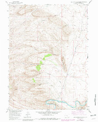
1953 Map of Lone Haystack Mountain
USGS Topo · Published 1982About this map
The North Platte River snakes through the southern reaches of this Carbon County landscape, carving through the Fort Steele Breaks as it flows east toward Cedar Ridge. This 1953 survey, with updates from the early 1980s, illustrates a high-desert terrain defined by seasonal drainages and essential water sources. These vital points are clearly marked by named features like Wise Dugout Springs and Lower Dugway Spring, which likely served as critical landmarks for early travelers and livestock. The area's topography is dominated by the namesake Lone Haystack Mountain and the uniquely named Stinkhole. Human infrastructure is sparse but notable, including the north-south transit of the Seminoe Road and a long-distance Pipeline, reflecting the region's role as a corridor for transport and energy movement within the wider Missouri River Basin development project.
Find a feature on this map
18 named features on this map. Tap any name to fly to it.
Don’t see what you’re looking for? This feature index may not catch every label — zoom into the map to look around manually.
Map Details
Editions of this 1953 Lone Haystack Mountain Map
3 editions found
Other maps of this area

1893 · Fort Steele
USGS Topo · 1:125,000

1914 · Walcott
USGS Topo · 1:62,500

1953 · Wild Horse Mountain
USGS Topo · 1:24,000

1953 · Sinclair
USGS Topo · 1:24,000

1953 · Seminoe Dam SW
USGS Topo · 1:24,000

1953 · Riddle Cut
USGS Topo · 1:24,000

1953 · Rawlins
USGS Topo · 1:24,000

1953 · Lone Haystack Mountain
USGS Topo · 1:24,000

1953 · Rawlins NW
USGS Topo · 1:24,000

1954 · Rawlins
USGS Topo · 1:250,000