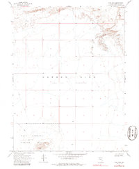
1969 Map of Lone Rock
USGS Topo · Published 1986About this map
Carson Sink dominates this interior portion of Churchill County, where the landscape is defined by the stark expanse of an Alkali Flat. Mapping in the late 1960s reveals a terrain mostly devoid of permanent water, characterized instead by shifting Sand Dunes and the isolated prominence of Lone Rock itself. This geologic feature stands as a landmark in a vast, arid basin where few man-made structures exist.
Find a feature on this map
8 named features on this map. Tap any name to fly to it.
Don’t see what you’re looking for? This feature index may not catch every label — zoom into the map to look around manually.
Map Details
Editions of this 1969 Lone Rock Map
3 editions found
Other maps of this area

1908 · Carson Sink
USGS Topo · 1:250,000

1910 · Carson Sink
USGS Topo · 1:250,000

1931 · Lovelock
USGS Topo · 1:250,000

1935 · Lovelock
USGS Topo · 1:250,000

1954 · Buffalo Mtn
USGS Topo · 1:62,500

1955 · Lovelock
USGS Topo · 1:250,000

1956 · Lovelock
USGS Topo · 1:62,500

1957 · Reno
USGS Topo · 1:250,000

1959 · Lovelock
USGS Topo · 1:250,000

1959 · Reno
USGS Topo · 1:250,000