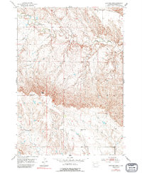
1953 Map of Lone Tree Creek
USGS Topo · Published 1994About this map
The high plains of Meade County unfold across this 1953 survey, centered on the drainage networks of Alkali Creek, Lone Tree Creek, and Antelope Creek. This landscape is defined by the sparse markers of early rural education and the topographic prominence of Costello Point. The map provides a precise look at the mid-century spatial distribution of school districts in this portion of South Dakota, showing both the active Prairie View Sch and the already defunct Morse Creek Sch (Abandoned). These small, localized landmarks are often the only remaining evidence of the family ranching clusters that once utilized these specific watercourses for survival. The transition from active to abandoned status for these rural schoolhouses reflects the shifting population density and the consolidation of rural communities during the postwar era.
Find a feature on this map
6 named features on this map. Tap any name to fly to it.
Don’t see what you’re looking for? This feature index may not catch every label — zoom into the map to look around manually.
Map Details
Editions of this 1953 Lone Tree Creek Map
3 editions found

Other maps of this area

1893 · Rapid
USGS Topo · 1:125,000

1898 · Rapid
USGS Topo · 1:125,000

1903 · Rapid
USGS Topo · 1:125,000

1953 · Bend
USGS Topo · 1:24,000

1953 · Rapid City 1 SW
USGS Topo · 1:24,000

1953 · Rapid City 1 NW
USGS Topo · 1:24,000

1953 · Hereford
USGS Topo · 1:24,000

1953 · Rapid City NW
USGS Topo · 1:24,000

1953 · Hereford SW
USGS Topo · 1:24,000

1953 · Rapid City 1 NE
USGS Topo · 1:24,000