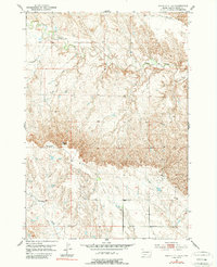
1953 Map of Rapid City 1 SE
USGS Topo · Published 1989About this map
Alkali Creek and Lone Tree Creek define the drainage of this Meade County landscape as it appeared during the early 1950s. The terrain is dominated by the sharp rise of Costello Point, marking a transition from the lower creek bottoms to the higher plateaus. While the area is primarily rural and characterized by wide-open drainage basins, the presence of educational landmarks like the Prairie View Sch suggests a community structure tied to the surrounding ranching or farming lands. A notable detail for local historians is the Morse Creek Sch (Abandoned), which by the time of this field check in 1953, already stood as a silent marker of earlier settlement patterns. Further south, Antelope Creek meanders through the township, illustrating the sparse but vital water network of the South Dakota plains.
Find a feature on this map
8 named features on this map. Tap any name to fly to it.
Don’t see what you’re looking for? This feature index may not catch every label — zoom into the map to look around manually.
Map Details
Editions of this 1953 Rapid City 1 SE Map
3 editions found

Other maps of this area

1893 · Rapid
USGS Topo · 1:125,000

1898 · Rapid
USGS Topo · 1:125,000

1903 · Rapid
USGS Topo · 1:125,000

1953 · Bend
USGS Topo · 1:24,000

1953 · Rapid City 1 SW
USGS Topo · 1:24,000

1953 · Rapid City 1 NW
USGS Topo · 1:24,000

1953 · Hereford
USGS Topo · 1:24,000

1953 · Rapid City NW
USGS Topo · 1:24,000

1953 · Hereford SW
USGS Topo · 1:24,000

1953 · Rapid City 1 NE
USGS Topo · 1:24,000