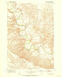
1953 Map of Rapid City 1 NE
USGS Topo · Published 1955About this map
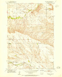
Belle Fourche River dominates this mid-century landscape in Meade County, winding through a series of pronounced meanders that define the local topography. This 1953 survey captures the rural character of the region just as modern infrastructure began to formalize earlier pioneer routes. Education and connectivity are marked by small, scattered landmarks including Bachand Sch and Hayes Sch, which served the outlying ranching and farming families of the northern Black Hills periphery. The transition from established river crossings like the Ford on the Belle Fourche to more formal paths like Alkali Road illustrates the slow shift in regional transport. Along with Elm Creek, these features reflect a landscape where water and distance dictated the placement of every schoolhouse and trail.
Find a feature on this map
7 named features on this map. Tap any name to fly to it.
Don’t see what you’re looking for? This feature index may not catch every label — zoom into the map to look around manually.
Map Details
Editions of this 1953 Rapid City 1 NE Map
2 editions found

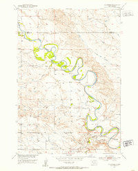
Other maps of this area

1893 · Rapid
USGS Topo · 1:125,000

1898 · Rapid
USGS Topo · 1:125,000

1903 · Rapid
USGS Topo · 1:125,000

1913 · Newell
USGS Topo · 1:125,000
1951 · Volunteer
USGS Topo · 1:24,000
1951 · Volunteer SE
USGS Topo · 1:24,000
1953 · Rapid City 1 SW
USGS Topo · 1:24,000
1953 · Rapid City 1 NW
USGS Topo · 1:24,000

1953 · Hereford
USGS Topo · 1:24,000
1953 · Hereford SW
USGS Topo · 1:24,000