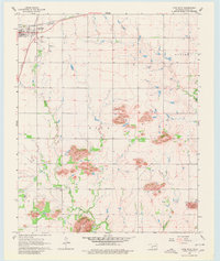
1964 Map of Lone Wolf
USGS Topo · Published 1980About this map
The town of Lone Wolf sits at the intersection of two major rail lines in the mid-1960s, reflecting its importance as a local transport hub. The Chicago Rock Island and Pacific and the Atchison Topeka and Santa Fe railroads define the northern part of the quadrangle, where the town layout includes a local Cemetery and a nearby Sewage Disposal site. To the south, the landscape shifts into a series of distinctive hills and peaks, including Tepee Mountain and Camelback Mountain.
Find a feature on this map
20 named features on this map. Tap any name to fly to it.
Don’t see what you’re looking for? This feature index may not catch every label — zoom into the map to look around manually.
Map Details
Editions of this 1964 Lone Wolf Map
2 editions found
Other maps of this area

1955 · Lawton
USGS Topo · 1:250,000

1955 · Clinton
USGS Topo · 1:250,000

1957 · Clinton
USGS Topo · 1:250,000

1961 · Hobart
USGS Topo · 1:62,500

1961 · Retrop
USGS Topo · 1:62,500

1963 · Babbs
USGS Topo · 1:24,000

1964 · Lone Wolf
USGS Topo · 1:24,000

1964 · Warren
USGS Topo · 1:24,000
1964 · Roosevelt
USGS Topo · 1:24,000

1971 · Blair
USGS Topo · 1:24,000