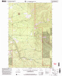
1999 Map of Loneman Creek
USGS Topo · Published 2003About this map
Thompson River State Forest and Lolo National Forest dominate this mountainous landscape in Sanders County, reflecting the deep integration of state and federal land management at the close of the twentieth century. The terrain is defined by the high crest of the Cabinet Mountains and the Corona Divide, which channel an intricate network of waterways toward the Thompson River.
Find a feature on this map
16 named features on this map. Tap any name to fly to it.
Don’t see what you’re looking for? This feature index may not catch every label — zoom into the map to look around manually.
Map Details
Editions of this 1999 Loneman Creek Map
This is the sole edition of this map. No revisions or reprints were ever made.
Other maps of this area

1937 · Thompson Falls
USGS Topo · 1:125,000

1956 · Wallace
USGS Topo · 1:250,000

1960 · Wallace
USGS Topo · 1:250,000

1964 · Calico Creek
USGS Topo · 1:24,000
1964 · Big Hole Peak
USGS Topo · 1:24,000

1964 · Coney Peak
USGS Topo · 1:24,000

1964 · Baldy Lake
USGS Topo · 1:24,000
1964 · Cook Mountain
USGS Topo · 1:24,000

1964 · Weeksville
USGS Topo · 1:24,000
1964 · Bassoo Peak
USGS Topo · 1:24,000