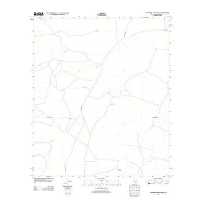
2012 Map of Loneman Mountain
USGS Topo · Published 2012About this map
Looney Ranch sits at the heart of this Culberson County landscape, where the management of water is the primary architectural feature of the terrain. The map illustrates a network of essential water resources, including numerous livestock tanks such as Dutch Girl Tank, Natural Spillway Tank, and Palomas Tank. These man-made and natural catchments, alongside East Windmill and South Windmill, reveal the infrastructure required for ranching in this arid part of West Texas.
Find a feature on this map
18 named features on this map. Tap any name to fly to it.
Don’t see what you’re looking for? This feature index may not catch every label — zoom into the map to look around manually.
Map Details
Editions of this 2012 Loneman Mountain Map
This is the sole edition of this map. No revisions or reprints were ever made.
Other maps of this area

1906 · Van Horn
USGS Topo · 1:125,000

1928 · Kent
USGS Topo · 1:125,000

1954 · Van Horn
USGS Topo · 1:250,000

1958 · Van Horn
USGS Topo · 1:250,000

1972 · Seven Heart Gap
USGS Topo · 1:24,000

1973 · Dellahunt Draw West
USGS Topo · 1:24,000

1973 · Two Mill Draw West
USGS Topo · 1:24,000

1973 · K C Ranch
USGS Topo · 1:24,000
1973 · Dome Hill
USGS Topo · 1:24,000
1973 · Delaware Ranch
USGS Topo · 1:24,000