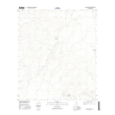
2016 Map of Loneman Mountain
USGS Topo · Published 2016About this map
Loneman Mountain anchors this high-desert landscape in northern Culberson County, where the terrain is defined by a network of drainage draws and livestock water management. Ranching infrastructure is the primary mark on the land, evidenced by numerous named catchment basins such as Palomas Tank, Cedar Tank, and the uniquely named Dutch Girl Tank. These water sources are linked by unpaved corridors including Smileys Rd and Weatherby Rd, illustrating the isolation and specialized land use in this part of Trans-Pecos Texas. The topography is etched by seasonal watercourses like Paint Horse Draw and Dellahunt Draw, which converge and diverge across the arid flats. Near the southern edge of the quadrangle, Pack Springs offers a rare natural water point in a region dominated by man-made tanks like Natural Spillway Tank and Division Tank.
Find a feature on this map
17 named features on this map. Tap any name to fly to it.
Don’t see what you’re looking for? This feature index may not catch every label — zoom into the map to look around manually.
Map Details
Editions of this 2016 Loneman Mountain Map
This is the sole edition of this map. No revisions or reprints were ever made.
Other maps of this area

1906 · Van Horn
USGS Topo · 1:125,000

1928 · Kent
USGS Topo · 1:125,000

1954 · Van Horn
USGS Topo · 1:250,000

1958 · Van Horn
USGS Topo · 1:250,000

1972 · Seven Heart Gap
USGS Topo · 1:24,000

1973 · Dellahunt Draw West
USGS Topo · 1:24,000

1973 · Two Mill Draw West
USGS Topo · 1:24,000

1973 · K C Ranch
USGS Topo · 1:24,000
1973 · Dome Hill
USGS Topo · 1:24,000
1973 · Delaware Ranch
USGS Topo · 1:24,000