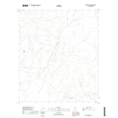
2019 Map of Loneman Mountain
USGS Topo · Published 2019About this map
Loneman Mtn and the eastern slopes of the Delaware Mountains define this high-desert landscape in northern Culberson County. The area’s water-dependent history is written in its numerous named basins, such as Natural Spillway Tank, Dutch Girl Tank, and Palomas Tank, which supported cattle ranching in a terrain marked by significant drainage systems like Paint Horse Draw and Horse Well Draw. Ranching infrastructure and remote transportation routes dominate the map, with Smileys Rd and FM 2185 providing the primary access through the scrub and limestone hills. Natural water sources are rare, making Pack Springs a critical landmark in the southeastern quadrant. This survey illustrates the specialized land use required in the Trans-Pecos region, where man-made tanks were essential to supplement ephemeral springs and seasonal runoff for livestock.
Find a feature on this map
18 named features on this map. Tap any name to fly to it.
Don’t see what you’re looking for? This feature index may not catch every label — zoom into the map to look around manually.
Map Details
Editions of this 2019 Loneman Mountain Map
This is the sole edition of this map. No revisions or reprints were ever made.
Other maps of this area

1906 · Van Horn
USGS Topo · 1:125,000

1928 · Kent
USGS Topo · 1:125,000

1954 · Van Horn
USGS Topo · 1:250,000

1958 · Van Horn
USGS Topo · 1:250,000

1972 · Seven Heart Gap
USGS Topo · 1:24,000

1973 · Dellahunt Draw West
USGS Topo · 1:24,000

1973 · Two Mill Draw West
USGS Topo · 1:24,000

1973 · K C Ranch
USGS Topo · 1:24,000
1973 · Dome Hill
USGS Topo · 1:24,000
1973 · Delaware Ranch
USGS Topo · 1:24,000