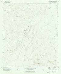
1973 Map of Loneman Mountain
USGS Topo · Published 1976About this map
Loneman Mountain rises above a landscape defined by the critical infrastructure of West Texas ranching in the early 1970s. This desert terrain is characterized by an extensive network of water management features, including isolated basins like Dutch Girl Tank, Windy Tank, and Natural Spillway Tank. The prominence of Looney Ranch and its associated Landing Strips suggests the scale of landholdings in Culberson County, where air travel often supplemented traditional ground transport across the vast draws. Water sources are meticulously mapped, from the East Windmill to the Brooks Well near the southern boundary, illustrating the lifeblood of the local cattle industry. Natural drainage patterns, such as Paint Horse Draw and Well Horse Draw, dictate the placement of these vital improvements, while a prominent pipeline cuts across the northern and southern sectors, marking the intersection of traditional ranching and modern energy transit.
Find a feature on this map
18 named features on this map. Tap any name to fly to it.
Don’t see what you’re looking for? This feature index may not catch every label — zoom into the map to look around manually.
Map Details
Editions of this 1973 Loneman Mountain Map
This is the sole edition of this map. No revisions or reprints were ever made.
Other maps of this area

1906 · Van Horn
USGS Topo · 1:125,000

1928 · Kent
USGS Topo · 1:125,000

1954 · Van Horn
USGS Topo · 1:250,000

1958 · Van Horn
USGS Topo · 1:250,000

1972 · Seven Heart Gap
USGS Topo · 1:24,000

1973 · Dellahunt Draw West
USGS Topo · 1:24,000

1973 · Two Mill Draw West
USGS Topo · 1:24,000

1973 · K C Ranch
USGS Topo · 1:24,000
1973 · Dome Hill
USGS Topo · 1:24,000
1973 · Delaware Ranch
USGS Topo · 1:24,000