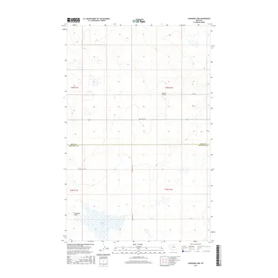
2017 Map of Lonesome Lake
USGS Topo · Published 2017About this map
Lonesome Lake anchors the southern expanse of this north-central Montana landscape, where the high plains meet the intricate drainage patterns of the Missouri River watershed. This modern 2017 survey by the U.S. Geological Survey documents a sparsely populated ranching and agricultural region spanning the border between Hill and Chouteau counties. The terrain is defined by dry washes and deep-cut glacial features, most notably Barneys Coulee and Twelvemile Coulee, which carve through the prairie. A grid of section-line roads and tracks like Box Elder Rd, Ihmsen Well Rd, and N Lonesome Lake Rd provide access to the vast interior. The presence of Ft 115 and various wells suggests a landscape optimized for livestock management and land resource extraction in a region where water is a precious commodity.
Find a feature on this map
13 named features on this map. Tap any name to fly to it.
Don’t see what you’re looking for? This feature index may not catch every label — zoom into the map to look around manually.
Map Details
Editions of this 2017 Lonesome Lake Map
This is the sole edition of this map. No revisions or reprints were ever made.
Other maps of this area

1904 · Boxelder
USGS Topo · 1:62,500

1906 · Lonesome
USGS Topo · 1:62,500

1906 · Boxelder
USGS Topo · 1:62,500

1919 · Big Sandy
USGS Topo · 1:125,000

1954 · Shelby
USGS Topo · 1:250,000

1958 · Shelby
USGS Topo · 1:250,000

1969 · Box Elder NW
USGS Topo · 1:24,000
1969 · Lonesome Lake
USGS Topo · 1:24,000
1969 · Big Sandy
USGS Topo · 1:24,000
1969 · Fourteenmile Coulee SE
USGS Topo · 1:24,000