
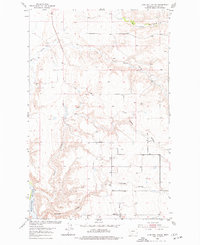
1953 Map of Lonetree Coulee
USGS Topo · Published 1955About this map
The Missouri River winds through the southwestern corner of this Chouteau County landscape, anchoring a complex network of dry coulees and seasonal creeks. Surveyed as part of a mid-century development program for the Missouri River Basin, the map documents a transition from the riverbanks to the high plains. Evidence of early rural education is preserved at the site of the Lonetree Sch (Aband), reflecting the shifting population patterns of Montana's ranching country in the early 1950s. The terrain is deeply incised by watercourses such as Lonetree Coulee, Alkali Coulee, and Crooked Coulee, which flow toward the larger drainage of Big Sandy Creek and Little Sandy Creek. A solitary Gravel Pit and the high point at VABM Notch stand as markers of human activity and topographical survey in this sparsely settled region.
Find a feature on this map
10 named features on this map. Tap any name to fly to it.
Don’t see what you’re looking for? This feature index may not catch every label — zoom into the map to look around manually.
Map Details
Editions of this 1953 Lonetree Coulee Map
2 editions found
Other maps of this area

1890 · Fort Benton
USGS Topo · 1:250,000

1892 · Fort Benton
USGS Topo · 1:250,000

1897 · Fort Benton
USGS Topo · 1:250,000

1919 · Big Sandy
USGS Topo · 1:125,000

1953 · Verona
USGS Topo · 1:24,000

1953 · Big Bend School
USGS Topo · 1:24,000

1953 · Pilot Rock
USGS Topo · 1:24,000

1953 · Havre
USGS Topo · 1:250,000

1954 · Great Falls
USGS Topo · 1:250,000

1954 · Shelby
USGS Topo · 1:250,000