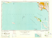
1960 Map of Long Beach
USGS Topo · Published 1960About this map
Long Beach and the massive urban expansion of Southern California anchor this 1960 coastal study, which highlights the dense grid of postwar settlements spreading inland toward Whittier and Montebello. While the mainland reveals a complex network of residential and industrial growth in places like Santa Fe Springs and Willowbrook, the vast Pacific Ocean dominates the majority of the view. The map provides a detailed record of the Channel Islands, showing the isolated terrains of Santa Cruz Island, San Nicolas Island, and the rugged coastlines of Santa Catalina Island with its prominent Avalon Bay. Strategic military and maritime features are visible at the coast, including Ft MacArthur Upper Reservation and the industrial infrastructure surrounding Terminal Island. This mid-century perspective captures the region just as the suburban sprawl was beginning to unify formerly distinct towns like Hynes and Clearwater into the modern metropolis.
Find a feature on this map
82 named features on this map. Tap any name to fly to it.
Don’t see what you’re looking for? This feature index may not catch every label — zoom into the map to look around manually.
Map Details
Editions of this 1960 Long Beach Map
2 editions found

Other maps of this area

1894 · Los Angeles
USGS Topo · 1:62,500

1894 · Pomona
USGS Topo · 1:62,500

1896 · Santa Ana
USGS Topo · 1:62,500

1896 · Pasadena
USGS Topo · 1:62,500

1896 · Anaheim
USGS Topo · 1:62,500

1896 · Redondo
USGS Topo · 1:62,500

1896 · Las Bolsas
USGS Topo · 1:62,500

1896 · Santa Monica
USGS Topo · 1:62,500

1896 · San Pedro
USGS Topo · 1:62,500

1896 · Downey
USGS Topo · 1:62,500